TYPE: Undergraduate Dissertation
LOCATION: Central Kalimantan, Indonesia
DATE: 27th September 2020 - 6th January 2021
METHODOLOGY:
- Satellite Imagery Mapping
- Photography
- Analytical Writing
- History Analysis
EQUIPMENT & SOFTWARE:
- Terrcolour Earthstar Satellite
- Adobe Creative suite
In Indonesia there are millions of indigenous who are suffering
with no legal tenure over their ancestral land; who are subsequently being excluded by private corporations who are supported by a capital hungry government. With a complex view on territory and an interrelated customary with no borders or distinctions, protected indigenous people from dispossession is posing to be an intricate task for all involved. An equally convoluted task is that of combatting territorial movements and techniques employed by a government; who shares very different views on territory, and how it should be used. Mapping as a methodology has a range of affects when imposed on the context of Central Kalimantan; some of which can be seen as contradictive, or a tool for territoriality. I will discuss the positives and negatives of counter-mapping techniques that can be deployed, as the ‘art of resistance’. I will then pose the debate of indigenous identity, and the affects of using the label of ‘indigenousness’ as a tool for affirming legitimacy of techniques. To summarise, I will conclude on discoveries I have made, and how their consequences will affect the future of indigenous land rights, and how major social reform must take place to allow for a balanced approach to be formulated.
with no legal tenure over their ancestral land; who are subsequently being excluded by private corporations who are supported by a capital hungry government. With a complex view on territory and an interrelated customary with no borders or distinctions, protected indigenous people from dispossession is posing to be an intricate task for all involved. An equally convoluted task is that of combatting territorial movements and techniques employed by a government; who shares very different views on territory, and how it should be used. Mapping as a methodology has a range of affects when imposed on the context of Central Kalimantan; some of which can be seen as contradictive, or a tool for territoriality. I will discuss the positives and negatives of counter-mapping techniques that can be deployed, as the ‘art of resistance’. I will then pose the debate of indigenous identity, and the affects of using the label of ‘indigenousness’ as a tool for affirming legitimacy of techniques. To summarise, I will conclude on discoveries I have made, and how their consequences will affect the future of indigenous land rights, and how major social reform must take place to allow for a balanced approach to be formulated.
Kawasan Hutan – Forest Estates
Swiddening – A form of rotational forest management of clearing forest for cultivation.
Durian Trees – Trees of long life that are reference points of territory that hold sacred importance, as the planter or their ancestors claim this land as their own
Reformasi – The period post-Suharto, which contained the decentralization of power from the state to regional administrations
Adat – Indigenous customary law and practice
Dayak – Indigenous people of Kalimantan

introduction.
Indigenous people around the world are united by one pressing problem poses by this developing world; the struggle of obtaining legal rights their land, and the under pressures by external forces threatening their way of life. In Indonesia this no exception, with millions of people involved in conflicts over legal tenure, with a challenging government with a clashing ideology. I will be investigating these conflicts and methodologies, in relation to legality, territory and identity and how these interrelating topics work for and against the indigenous people of Indonesia. By critically analysing the practicality and theory of these methods I can being to construct a possible approach.
Reflecting on my 1st year manifesto between the relationship of ecology and technology, I wanted to choose a topic that allowed me to identify a larger problem facing the world, and how applying a method or a specific field of architecture could provide a potential approach. I now understand that the term ‘sustainability’ is an umbrella term that is made up of a plethora of interrelated things, that each pose their own set of problems. My topic, contains elements of different forms of sustainability, ranging from political, social and environmental, all within a context that has a variety of complexities. I situated my architectural ideals within this context after a trip to Sabah (Malaysian Borneo), where I witnessed first-hand the drastic land transformations that had already taken place. After listening to people discuss how these changes are affecting communities and the environment, I knew this was a topic that I wanted to investigate.
Indonesia as a signatory of UNDRIP (UN Declaration of the Rights of Indigenous Peoples) has a right to protect the rights of these indigenous communities, but the result is far from successful. AMAN (Indigenous People’s Alliance of the Archipelago) estimates that there are 50 to 70 million indigenous people in Indonesia, who are all faced with their own specific problems, in relation to their indigenous individuality.1
Within my 1st chapter I frame these complexities, by analysing the history of the state’s relatinoship to their indigenous people and how that has shaped the contestations of today; alongside the complicated legislations of both past and present, that has affected land transformations throughout modern history. Using Central Kalimantan as a key case study, I also present deviating examples to show how the problem is by no means isolated. I use this chapter to exhibit, the drastically different views on territory that are present within this context; indigenous communities, the nation-state, regional administrations and private corporations who all impose their own forms of territory on this contested area. To further the scope of my question I use the thinking of Sack and Elden to provide contrasting opinions on territoriality, and to further my understanding into how territoriality is imposed on my context. The 2nd chapter begins to discuss mapping as a possible solution, and the debate of legitimacy that it surrounds this process; but I also consider it’s negative connotations such as territoriality, and how maps can be a visualisation of power and control.2
Firstly, I discuss how maps are a median; a surface layer that can be manipulated to impose a certain political view shared by the author. I explore these maps of bias by applying the thinking of Eyal Weizman. I also investigate techniques used by the state for delimitation and control, through this visual form of representation. I later discuss counter-mapping as a method, and its positive and negative connotations; I then propose Forensic Architecture’s methodology as an improved thematic. In the 3rd chapter I describe the intimate relationship that the indigenous narrative shares with the territory in which it resides. I then discuss the debate of identity, and how indigenousness can be used as a method to affirm legitimacy, but at the same time there is a danger of defining such a word. Finally, I consider how the large array of narratives imposed on a territory, have had a contradictive effect on its original intension.
1 Aliansi Masyarakat Adat Nusantara (AMAN), Asia Indigenous Peoples Pact (AIPP), The Situation of Human Rights of Indigenous Peoples in Indonesia (2017), <http://www.aman.or.id/wp-content/u loads/2016/09 INDONESIA_AMAN_AIPP_UPR_3rdCycle.pdf> [accessed 8th November 2019]
2 Willem Van Der Muur, ‘Forest Conflicts and the Informal Nature of Realising Indigenous Land Rights in Indonesia’, Citizenship Studies, 22. 2 (2018), 160-174 (p. 161).
contestations.
CONFLICT LEGISLATION
To understand the contestations of today, I must recall crucial moments in Indonesia’s history to recognize how this has shaped the social, political and economic landscape in which my stakeholders are so heavily invested (figure 1). Indonesia has a complex history of excessive colonial rule and relentless authoritarian control which has had a detrimental effect on the livelihoods of indigenous communities. These conflicts are not limited to state-settlers or governmental administrations, but they are domestic and international, and deeply intwined with global market forces, regional fights for power and vulnerable indigenous communities.
Throughout colonial rule, all control resided with the Dutch Forest Services, who declared all forests as ‘unclaimed’ under the Agrarian Law of 1870.3 After the Second World War, and the UN Declaration of (Resolution 1541) Granting Independence to Colonial Countries and their Peoples; colonialism officially had ended in Indonesia after 126 years of occupation. This paved the way for the ‘Old Order’ of President Soekarno, and then later in 1967 the ‘New Order’ of President Suharto authoritarian regime. Suharto, repaired relationships with the West, centralised the government and encouraged international investment; with the passing of the Basic Forestry Law in 1967, this declared that 143 million hectares (70% of Indonesia’s total land mass) of Kawasan hutan (customary forest territories) was under control of national government.4 What followed was the diaspora of concessions and permits, to large-scale foreign and domestic companies to begin the era of land transformation and the conflict of privatisation. “All land use and access require exclusion of some kind”.5 This was no exception for the Dayak people of the regions of Kalimantan, as these legal changes did not consider their adat law or customary practices of collective forest management. This has resulted in relentless conflicts over territories, and more commonly the dispossession of indigenous communities.
Post-Suharto, during the period of reformasi, the power decentralised resulting in regional heads of state obtaining far more freedom and control. What ensued, was even larger concessions being granted to private companies, as this resulted in high levels of personal gain for the regional heads of state; this put indigenous communities at a disadvantage within the competition to obtain legal rights to land.6 The indigenous fight for territory is also belittled by the hand of global economic forces, in which “trans-local capital and production flows are the drivers for national productivity and territorial sovereignty”.7 Which Appadurai, argues has resulted in ‘alienation twice intensified’ within an increasingly complex global view on spatial organisation. This is evident within West Papua, an absorbed region of Indonesia, that has one of the richest coppers and gold deposits within the archipelago. The independence vote of West Papua (‘Act of Free Choice’ in 1969), was labelled as being ‘manipulative’ and a ‘completely controlled’ referendum in which the Indonesian government absorbed their region as part of the republic.8 Among a plethora of other social reasons, which motivated this occupation, in turn they assumed control of a the Freeport Grasberg Mine; Indonesia’s single highest tax payer.9 This territory has been a nexus of environmental violence, at an unprecedented scale that has impeded the livelihood of many indigenous communities who reside in these hinterlands.
3 Krystof Obidzinski and Koen Kusters, ‘Formalizing the Logging Sector in Indonesia: Historical Dynamics and Lessons for Current Policy Initiatives’, Society & Natural Resources, 28. 5 (2015), 530-542 (p. 532).
4 Kristina Großmann, ‘Dayak, Wake Up - Land, Indigenity and Conflicting Ecologies in Central Kalimantan, Indonesia’, Journal of Humanities and Social Sciences of Southeast Asia, 175. 1 (2019), 1-28 (p. 2)
5 Esteve Corbera, ‘Powers of Exclusion: Land Dilemmas in Southeast Asia’, Journal of Peasant Studies, 39. 1 (2012), 221-225 (p. 221)
6 Paul K. Gillert, ‘The Quest for Legal Certainty and the Reorganization of Power: Struggles over Forest Law, Permits and the Rights in Indonesia’, The Journal of Asian Studies, 74. 3 (2015), 639-666 (p. 640)
7 Arjun Appadurai, ‘Disjuncture and Difference in the Global Cultural Economy’, Theory, Culture & Society, 7. 295 (1990), 295-310 (p. 306)
8 Thomas D Musgrave, ‘An analysis of the 1969 Act of Free Choice in West Papua’, in Sovereignty, Statehood and State Responsibility: Essays in Honour of James Crawford, ed. by Christine Chinkin, Freya Baetens (Cambridge: Cambridge University Press, 2015), pp. 209-228 (p. 220)
9 Nabil Ahmed, ‘The Toxic House’, in Forensis: The Architecture of Public Truth, ed. Forensic Architecture (Oberhausen, Germany: Sternberg Press, 2014), pp. 614-633 (p. 625)

Figure 1 - Shows the varying web of interconnected contestations that are both domestic and international
DAYAK FOR SALE
Amongst this clash of contestations, lies one common denominator of such salience. Territory is either the prize, product or mediator of the proliferation of scenarios that the government has enabled. Territory carries vastly different meanings for all stakeholders involved within this Indonesian context, which adds to the complexity of the challenge of trying to establish an approach. To provide an insight into this complexity, I will be showcasing the Dayaks of Central Kalimantan, and how their rotational agroforestry is interconnected to a heterogeneous range of dependencies.10 Territory for Dayak groups is such a hard thing to define as it is deeply rooted within their sacred and ancestral history. Their terms of engagement with their environment depends heavily on access to forest products, areas where spirits reside and the ability to engage in traditional adat rituals.11 Semi-nomadic in nature, Dayaks uphold a very dynamic and fluid way of life that revolves around their ability to cultivate and circulate with in their forest as a whole in relation to ancestral and labour rights of previous occupants; such as the significance of durian trees or swiddeners for example (a form of Dayak cultivation) (figure 2).12
The mechanism of succession and territory, works by inheritance and the communication of oral histories; as they have no desire or need to physically record any aspects of ownership, until being pressured by external forces. Much to the argument of geographical theorists, I conclude that indigenous ideals of territory isn’t something that is bound by geographical boundaries or even a specific geographical site for that matter; their territory is embedded within the land as a whole, and the narrative that the land conceives. Subsequently down to their customary practices and these dynamic boundaries they are vulnerable to alienation and losing their territory to exploitation; all through to western influenced methods of control. In contrast to the states conventional western perspective, is that territory is a commodity, that is moulded by property as a something that can be ‘bought and sold’.13 This Marxist perspective on western ideology, is supported by Sack when he states that throughout western history land has always been divided up by ownership and function into saleable packages.14 On a correlative path, private corporations view territory as an object for capital extraction, usually with little regard for rules and regulation; in the case of Grasberg Mine their power over the government is evident. These invasion of permits and little care for indigenous land tenure is present within Central Kalimantan (figure 3 & 4).15
10 Nancy Lee Peluso, ‘Whose Woods are These: Counter-Mapping Forest Territories in Kalimantan’, Antipode, 27. 4 (1995), 383-404 (p. 394)
11 Kristina Großmann, ‘Dayak, Wake Up - Land, Indigenity and Conflicting Ecologies in Central Kalimantan, Indonesia’, (p. 4)
11 Kristina Großmann, ‘Dayak, Wake Up - Land, Indigenity and Conflicting Ecologies in Central Kalimantan, Indonesia’, (p. 4)
12 Nancy Lee Peluso, ‘Whose Woods are These: Counter-Mapping Forest Territories in Kalimantan’, (p. 393)
13 Edward W Soja, ‘The Political Organisations of Space’, (Washington DC: Association of American Geographers, 1971), p. 9
14 Robert David Sack, ed., ‘Human Territoriality: Its Theory and History’, (London: Cambridge University Press, 1986) p. 10
15 Forensic Architecture, Forensic Architecture: Ecocide of Indonesia (31.03.2017) <https://forensic-architecture.org/investigation/ecocide-in-indonesia> [10/11/2019]

Figure 2 - This diagram shows how the Indonesian government view territory as plots for sale; and how the contrasting indigenous view if far more fluid.


WEAPONISED TERRITORIALITY
Territoriality, though by different methodologies has been present in Indonesia since colonial times, now being applied by the current administration this subsequently poses a threat to the territories of indigenous populations. Territoriality as defined by Sack: “as the attempt by an individual or group to affect, influence, or control people, phenomena, and relationships, by delimiting and asserting control over a geographic area”.16 Obviously the necessity is there to treat both these phenomena as entities in their own right, but if territoriality is the use to territory as a tool to control social relations; this subsequently implies that Sack considers territory to be of social construction. This is discussed further by Elden who argues that “this is a satisfactory social ontology of territoriality” but isn’t sufficient to define it; as this ‘enquiry is un-specific in nature’.17 Elden explains that territory is dynamic, because at times territory can just be place and enforce no aspects of social control, and that territory is something that has to be maintained.18 This is supported by the Dayak narrative, as its only from the point a tree is planted that aspects of territoriality are employed; as this means that swiddening cannot take place. With only viewing territoriality as a social construct limits the scope under which it can be applied; it also carries biological, geographical and political connotations. The government engages in territoriality when any actor of the state or associated organisations undertake an attempt to classify, communicate or enforce boundaries, physically or socially within a specific area.19 This is a very challenging process to complete equitably within the context of the Dayak people of Central Kalimantan; as I will discuss in the next chapter. Within today’s society, whether dubbed as ‘western’ or not people must take some form of control to find their place within society. The update on the Forestry Law in 1999, now states that access can be provided to indigenous people if the state recognises an adat customary community and if they are in accordance with societal development. This provides an opportunity for ‘counter-measures’ to ensure the land rights of indigenous communities are secure.
16 Robert David Sack, ed., ‘Human Territoriality: Its Theory and History’, p. 19
17 Stuart Elden, ‘Land, Terrain, Territory’, Process in Human Geographies, 36. 6 (2010), 799-817 (p. 802)
18 Stuart Elden, ‘Land, Terrain, Territory’, (p. 802)
19 Robert David Sack, ed., ‘Human Territoriality: Its Theory and History’, p. 21
17 Stuart Elden, ‘Land, Terrain, Territory’, Process in Human Geographies, 36. 6 (2010), 799-817 (p. 802)
18 Stuart Elden, ‘Land, Terrain, Territory’, (p. 802)
19 Robert David Sack, ed., ‘Human Territoriality: Its Theory and History’, p. 21
(counter) notions of the grey area.
THE SURFACE LAYER
Land transformation is a chaotic process of exclusion, which results in social tactics for securing rights to land. Before I can discuss such countermeasures of territoriality, I must first analyse the method being implemented, and the limitations and the connotations in which come so deeply entwined. Mapping in its most simple form is the study of geography to record and denote aspects of a landscape; this is a naive perspective on a practice which carries connotations of power and the ability of social control.20 To understand this practice I must divulge, how representational practices specifically those fixed by geo-spatial elements carry the capability of legal stature. During an International Court of Justice case in 2004, between Israel and Palestine, a topographic model was presented by both sides to aid in negotiations. These models where to contest a wall being built that had excluded 300 acres of fields from Palestinian farmers, along the occupied West Bank.21 These models allowed for advanced topographical considerations along the route of the wall, that took into account the external factors, such as security considerations of high ground. This is a compelling precedent of how an object can be designed to be the instrument of such dispossession; this is evident in the practice of mapping.22 The state have used maps as an attempt to affirm their control over territories, which are deemed to be the property of the state. By delimiting and defining boundaries within a territory they are excluding those who occupy that territory who otherwise have no legal tenure. The current methods of mapping employed by the current administration portray surface level information, upon what is a far more complex indigenous context; hence why they have met such opposition. These maps of conquest have failed to understand the dynamic processes of the indigenous, subsequently short-circuiting their history to only obtain a homogenous surface layer; and thus, undertaking in unjust territorialisation (figure 5). Applying the indigenous context to Eyal Weismann’s framework, translates to the ‘event’ being the territorialisation of indigenous lands, the ‘object’ being maps, the tool of territorialisation and finally the ‘forum’; a legal audience.23
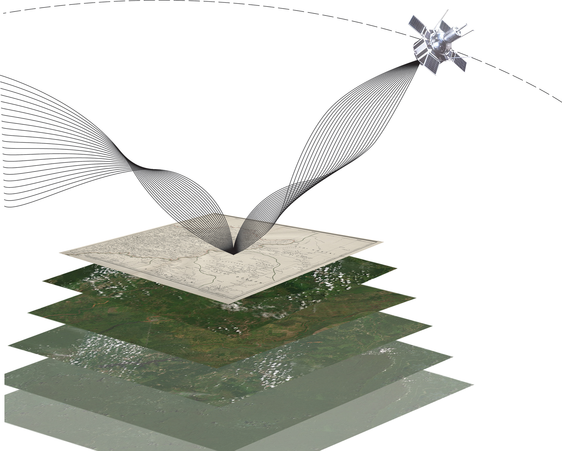
Figure 5 - This diagram shows the limitations of satellte imagery and how this form of analysis doesnt penetrate through the ‘surface layer’.
The flaw within this framework is the object, as seen in the West Bank context when the object is presented by an individual or group this is to support their own motives, this object becomes tainted with levels of bias. The object then becomes a manipulation of the authors own expression, and in turn blurs this delineation between reality and representation (figure 6). If maps are the physical manifestation of this surface layer, and these maps are subjects of bias, which, by definition; cannot legally stand as they undermine the very legitimacy that they claim to uphold. Maps just as the model presented to the Israeli Court, can be manipulated not always in such literal forms of changing aspects to suit ones will; but mapping without considering the political and social elements on the ground, is manipulation through ignorance.
State mapping processes, find comfort within the isolated use of satellite imagery but to “engage with aerial sightedness is to yield completely to the problems posed by the surface”; and therefore, neglect to acknowledge the customary culture on the ground.24 State territorial legitimacy is bound by geographical boundaries defined by maps, which when in comparison with the indigenous dynamic way of life, renders this form of mapping unsuitable for this context. To begin to create a median within this political arena, one must combine indigenous knowledge and scientific methodologies. This was present within Forensic Architecture’s counter-mapping operation in West Papua, in response to the tailings (deposition of residue) of the Freeport Grasberg mine. “Ancient, generational, territorial rights and sacred land are recorded and incorporated with geo-reference data, geographical contours and fieldwork data”, only through this superimposition of layers of data and indigenous knowledge, could a possible approach be constructed to protect customary forests (figure 7).25 Applying indigenous knowledge onto a map reduces short-sightedness, and opens up this surface layer for a range of interpretations; allowing a two way negotiation to open up. This is in contrast to the one-sided, one layered, territorial maps that the state have created. As evident with Forensic Architecture’s methodologies, depth of place can be achieved by far more than just contours on an OS map, and other methods exist to expand the scope for indigenous cartography.
20 Brenda Parker, ‘Constructing Community Through Maps? Power and Praxis in Community Mapping’, The Professional Geographer, 58. 4 (2006), 470-484 (p. 471)
21 Eyal Weizman, ‘The Least of all Possible Evils: Humanitarian Violence from Arendt to Gaza’, (London: Verso, 2011) p. 66
22 Eyal Weizman, ‘The Least of all Possible Evils: Humanitarian Violence from Arendt to Gaza’, p. 78
23 Eyal Weizman, ‘The Least of all Possible Evils: Humanitarian Violence from Arendt to Gaza’, p. 106
24 Ryan Bishop, ‘Transparent Earth: The Autoscopy of Aerial Targeting and the Visual Geopolitics of the Underground’, in Forensis: The Architecture of Public Truth, ed. Forensic Architecture (Oberhausen, Germany: Sternberg Press, 2014), pp. 580-590 (p. 583)
25 Nabil Ahmed, ‘The Toxic House’, (p. 628)
25 Nabil Ahmed, ‘The Toxic House’, (p. 628)
LEGITIMACY OF THE LESSER EVIL
A metaphor that resembles state mapping ideologies, can be described as recording where a person slept on a specific night, and disregarding where they sleep normally, where they slept and who they slept with.26 This metaphor describes, how the current administration and partnering corporations view territory as something which is black or white; thus ‘justifying’ their continued use of mapping techniqueshat are void of a socially deeper layer that the indigenous context desires. Viewing territory as strictly black or white, or as commodity, makes the delimitation and creation of boundaries a relatively simple process as land is either owned or has been sold. The map as some would argue, embodies that of the ‘lesser evil’; a mechanism which continues, instead of bringing around change.27 This is supported by Edward Said who described mapping as the ‘art of war’ as he related it back to its inception as a colonial tool of conquest; but also can be the ‘art of resistance’ if a counter-strategy ensued.28 Mapping does not always involve the reifying of power, it can also be interpreted as a universal language of protest, which can be understood within any context; counter-mapping is the manifestation of these ideals. If mapping lies within this meaning of social construction, only accuracy of scale and a set of common numerical parameters can ensure legitimacy.29 If legitimacy is only affirmed by bodies of authority, this must render legitimacy as a subjective term; due to different stakeholders assuming drastically different levels of control. This in turn, implies that the boundaries drawn on state maps carry a perceived sense of legitimacy depending on where someone situates themselves politically Legitimacy for community mapping, and for maps completed by NGO’s can be affirmed by appropriating the visual methods and techniques applied by the state. In doing this, there is no controversy over differing scales or numerical methodologies, which allows for a more equal comparison and no conflicts over representation. Although, through doing this, a map is still an object that is naturally limited for indigenous use, due to the fact that once a map is designed, it is then a fixed object in time with no scope for growth or development, this doesn’t conform to changing territories of Dayak semi-nomadic culture. Although, the process and the method of mapping is something that can be dynamic, and the people that engage in this form of territorial visualisation can also fluctuate; as seen previously in Forensic Architecture’s methodologies.30
26 Richard Dennis, ‘Cities in Modernity: Representations and Productions of Metropolitan Space’, 1840-1930’, (Cambridge: Cambridge University Press, 2008), p. 69
27 Eyal Weizman, ‘The Least of all Possible Evils: Humanitarian Violence from Arendt to Gaza’, p. 6
28 Edward W Said, ‘The Politics of Dispossession: The Struggle for Palestinian Self‐Determination’, 1969–1993’, (New York: Pantheon Books, 1994), p. 19
27 Eyal Weizman, ‘The Least of all Possible Evils: Humanitarian Violence from Arendt to Gaza’, p. 6
28 Edward W Said, ‘The Politics of Dispossession: The Struggle for Palestinian Self‐Determination’, 1969–1993’, (New York: Pantheon Books, 1994), p. 19
29 Laura Vaughan, ‘Mapping Society: The Spatial Dimensions of Social Cartography’, (London: UCL Press, 2018), p. 5
30 Dennis Wood, ‘The Power of Maps’, (London: Routledge, 1993), p. 32
30 Dennis Wood, ‘The Power of Maps’, (London: Routledge, 1993), p. 32

Figure 6 - This diagram shows how reality can become representation, in this case a model.
THE INTANGIBLE NARATIVE
In contrast, mapping has been used to visualize social correlations between aspects of the visible, and patterns of the invisible; therefore highlighting complexities, previously overlooked within society.31 Using Charles Booth’s maps as an example, by mapping breakouts of cholera in the Jewish areas of 18th century London, which inherently relied on poor sanitation to exist, mapping managed to record the social pauperization of class divides at that time; a subject matter that was believed to be intangible. The problem of intangibility is intrinsically connected to the context of indigenous people, as their systems of territory rely on the ancestral lineage of durian trees and labour rights of cleared swiddens. Due to this complexity, NGO’s have played a contradictive part in the mapping of indigenous territories but also have succeeded in some cases, providing legal land tenure for its indigenous occupants. The inception of most common conflicts arises from NGO’s having to apply some form of border distinctions, which can differ in methodology, but more ultimately result in a form of territorialization between groups or against the state. It’s the process of defining borders which most communities cannot agree, arguing that the dynamic borders were never needed in the past; that this is just a product of expansive modernity. The deployment of indigeneity can be also be an effective method in strengthening legitimacy of counter-maps; by strengthening indigenous identity this renders the map a more powerful tool for political mobilization.32 As proven by the success of the ‘Dayak Misik’ program in Central Kalimantan, where farmers have obtained legal rights to land, by enacting their adat customary land rights without defining boundaries.33 This although didn’t come without conflict, as the regional government of Central Kalimantan is reluctant to give up territorial power. Although on the contrary to the patterns of history, these conflicts also came domestically between different Dayak groups; a topic which I will expand on in the next chapter.
31 Laura Vaughan, ‘Mapping Society: The Spatial Dimensions of Social Cartography’, p. 19
32 Willem Van Der Muur, ‘Forest Conflicts and the Informal Nature of Realising Indigenous Land Rights in Indonesia’, Citizenship Studies, 22. 2 (2018), 160-174 (p. 164)
33 Kristina Großmann, ‘Dayak, Wake Up - Land, Indigenity and Conflicting Ecologies in Central Kalimantan, Indonesia’, (p. 11)
32 Willem Van Der Muur, ‘Forest Conflicts and the Informal Nature of Realising Indigenous Land Rights in Indonesia’, Citizenship Studies, 22. 2 (2018), 160-174 (p. 164)
33 Kristina Großmann, ‘Dayak, Wake Up - Land, Indigenity and Conflicting Ecologies in Central Kalimantan, Indonesia’, (p. 11)

Figure 7 - This diagram resembles how Forensic Architecture applied indigenous knowledge to geographic contours, to begin to create a form of mapping which is more compatible to this context. This diagram shows the indigenous method of memory mapping, and how they circulate through a space using rivers, trees and mountains as reference
a paradoxical nation.
IDENTITY IN QUESTION
The famous slogan from President Suharto’s ‘New Order’ regime, is that Indonesia is a country of no indigenous people, as every single Indonesian is equally indigenous; which undermined any international declaration surrounding indigenous people.34 This reveals the value the indigenous identity held within the Suharto administration; if it isn’t defined, recognised nor does it comply with regional or national forms of development it would be undercut or disregarded. Indigenous land reform backed by these external pressures create conflicts with the indigenous people, as constrains on land intensifies, this results in less cohesion between indigenous groups; individualization of adat practices ensue, resulting in a weakened indigenous identity and increasingly vulnerable communities.35 Indigenous identity relies so heavily within the territory in which it resides. Although indigenous territory is not being fixed by boundaries, geo-spatial conditions, their identity is dependant within their narrative that their land has enabled. The land is rendered of paramount importance, to the durian trees, swidden cultivation and management through the prioritization of forest resources, that defines the Dayak indigenous people and their adat practices. Therefore, as these external pressures are applied, and more indigenous land is being privatised and transformed; this is in affect is removing indigenous identity. This connection to land is affirmed by Peluso, when discussing the construction of ‘natives’, she describes how “when Europeans first arrived in Borneo, they found that both Muslim and non-Muslim rural people identified themselves by the names of their local rivers or other place names”.36 Indigenous identity carries a history of confrontation, and engagement, when in reality this stigma is present due to that of colonialism, military occupation and environmental violence.37 The Indonesian state took advantage of this stigma, by using history as a tool to label the indigenous people as ‘primitive, backwards and undeveloped’, with the ulterior motive of labelling their land as ‘unproductive’ so they could justify claiming land under the Basic Agrarian Law (1960), with the land not being used for ‘national interest’.38 Using identity as a way of imposing territoriality, implies that indigenous identity is an object of social construction.
This is supported by Short, who claims that indigenous identity has been created through the construction of interests, an entity that can be morphed to support different angles and motives within society.39 This theory is a problem when applied to the designation of indigenousness, within Article 67 of the 1999 Forestry Law which proposes that a community must first be recognised by the state, to lay claim to any forest territories. To be ‘recognised’ a community must prove their practice of adat customs and have their ‘Dayakness’ tested. This presents a difficult question of who has the authority to define the indigenousness of communities? This lack of definition poses a familiar type of problem for indigenous people which takes shape in the form of legality, without a fixed definition of indigenousness there will be always be a lack of legal strength. Although, with the context being so complex with variations of adat law being evident, within almost every indigenous community, this creates a problem in defining such a term. Who is or isn’t indigenous? This is a topic which has created many conflicts within the indigenous community.
34 Aliansi Masyarakat Adat Nusantara (AMAN), Asia Indigenous Peoples Pact (AIPP), The Situation of Human Rights of Indigenous Peoples in Indonesia (2017), <http://www.aman.or.id/wp-content/uploads/2016/09/INDONESIA_AMAN_AIPP_UPR_3rdCycle.pdf> [accessed 8th November 2019]
35 Ketut Deddy, ‘Community Mapping, Tenurial Rights and Conflict Resolution in Kalimantan’, in State, Communities and Forests in Contemporary Borneo, ed. by Fadzilah M Cooke (Canberra: Australian National University Press, 2006), pp. 89-110 (p. 93)
36 Nancy Lee Peluso and Micheal Watts, ed., ‘Violent Environments’, (New York: Cornell University Press, 2001) p. 97
37 Micheal R. Dove, ‘Indigenous Peoples and Environmental Politics’, Annual Review of Anthropology, 35 (2006), 191-208 (p. 193)
38 Nancy Lee Peluso and Micheal Watts, ed., ‘Violent Environments’, p. 101
39 Damien Short, ‘The Social Construction of Indigenous ‘Native Title’: Land Rights in Australia’, Current Sociology, 55. 6 (2007), 857-876 (864)
CONDRADICTIONS
Exclusion cannot only be considered as a top-down mechanism; exclusion can occur from ‘below’ as well as from the side.40 This is evident within Central Kalimantan where indigenous groups have been accused of deploying a more dominant form of ‘indigenousness’ for political and geographical gain. People naturally identify with certain communities because they correlate with personal beliefs and ideologies. Foucault proposes his theory of ‘dividing practices’, “where one community objectifies another and privileges the self, through assumed distinctions of right and wrong, rich or poor, sick or healthy”, or in this case more or less ‘Dayak’.41 This is evident within Central Kalimantan, where villages have been objectifying each other depending on whether they have deviated from the ‘fixed’ Dayak identity. The village of Tumbang Batubara, is a perfect example of a ‘lesser evil’ relationship between an indigenous community and a private corporation; as they have developed a patron-client relationship (Figure 8).42 The company provides, infrastructure, clean water and medical supplies that wouldn’t be provided by the regional administration, in return they surrender ancestral land that had been passed down through generations of a single family’s lineage.
This exposes the villagers to further exploitation, for simple services that should otherwise be provided by the state. Similar transactions are present, but are far more class related, as village leaders have been known to accept cash bribes to allow certain activities to take place; this ironically embodies processes of colonialism, and therefore implies drastic deviations of indigenous identity. This has caused major conflict within Central Kalimantan, how communities are ‘evolving’ from their previous adat ways. In terms of the Dayak Misik scheme in Central Kalimantan, has been successful in terms of asserting legal control over parts of indigenous territories, through the means of counter-mapping and combining different types of territory. Although the counter-mapping scheme has clashed with how specific groups view and value territory; such as Punang Murang, who’s dynamic ancestrally place-based territory doesn’t conform with the ‘state-style’ territorialisation methods the Dayak Misik scheme have put into practice.43 This has reflected methods of colonialism, by defining boundaries and has received mixed responses. On the contrary, I propose that counter-mapping is a way of affirming a place within society, maybe it’s not a loss of identity but a community changing, adapting or by definition; being dynamic, to allow for a changing socio-political landscape in which they reside.
Dayak communities have challenged others in terms of conformation to the governments criteria for classification of Dayak indigenousness; which carries strong aspects of territorialisation. 44 This ever present cultural adjustment, has resulted in indigenous identity changing in some ways after years of persecution and labelling as ‘backwards’, is this a change which was inevitable in relation to an ever-commoditized world; or was it a forced change to make the best of a bad situation? This theory proposes that indigeneity is something that can be reinvented, revealing a different realm of interpretation surrounding indigenousness identity.
40 Esteve Corbera, ‘Powers of Exclusion: Land Dilemmas in Southeast Asia’, (p. 224)
41 Michel Foucault, ‘The Subject and Power’, in Michel Foucault: Beyond Structuralism and Hermeneutics, ed. by Hubert L. Dreyfus and Paul Rabinow (Sussex: The Harvester Press Limited, 1982), pp. 208-226 (p. 208)
42 Kristina Großmann, ‘Dayak, Wake Up - Land, Indigenity and Conflicting Ecologies in Central Kalimantan, Indonesia’, (p. 13)
43 Kristina Großmann, ‘Dayak, Wake Up - Land, Indigenity and Conflicting Ecologies in Central Kalimantan, Indonesia’, (p. 4)
44 Robert David Sack, ed., ‘Human Territoriality: Its Theory and History’, p. 32
45 Jeremie Gilbert, ‘’Historical Indigenous Peoples Land Claims: A Comparative and International Approach to the Common Law Doctrine on Indigenous Title’, International and Comparative Law Quarterly, 56. 3 (2007), 583-612 (p. 587).

Figure 8 - This collage shows how the past and present regimes have shaped the environment in which these private corporations work within, and how this encourages actions of the ‘lesser evil’.
INDIGENOUSNESS
Jeremie Gilbert proposes that the indigenous need one constant fixed identity, something which is fixed with one set of beliefs.45 In an ideal world, without the vast complexities of this Indonesian context, this theory would work in rectifying land rights; the implication of adat is the closest construct to achieving this. One umbrella term cannot consider all variations, not just adat, but the differing ritual processes, variations in ancestral inheritance and dynamic territorial aspects; within Central Kalimantan and the rest of Indonesia.
This question of identity has become extremely muddied over recent years, with the plethora of varying narratives in play within this context. In contrast to Gilberts theory, this implies that indigenous identity is something that is not a unified object, it is multiple, and contains a web of interconnected dependencies. “A book is not made up of individual words on a page, each of which has a universally valid meaning, but rather is, quote: “caught up in a system of references to other books, other texts, and other sentences”.46 Foucault’s metaphor of the book describes this context perfectly, as each variation of adat is valid in its own right but also has sacred histories that link every community; just like a book has pre-history that is not universally given but is constructed. This theory is present for the legal regulations and legislation, making the process very unclear.
Labelling, as previously explained carries connotations of control and manipulation; labelling someone as ‘indigenous’ also carries dangers to society. “Such efforts to protect indigenous could leave the vast majority, living on the periphery, in danger of not having access to legal land tenure, if they are not defined under this hazy definition”.47
By defining indigenousness, in turn excludes communities on the border of this definition, people who would be suffering with the same conflicts with only a differing customary practice. As explained further by Li, indigenousness is a concept that has been reworked and infected over time, as it has travelled around the world; gone from context to context, it has lost its potency.48 Li further elaborates that indigenousness is a methodology that can be deployed to combat, the legitimacy of maps or to affirm claims to tenure; this can be adopted to promote different agendas for indigenous communities, NGO’s and governments alike. This fluidity, theoretically works with the dynamic adat processes, but it is this flexibility that begins to dilute the potency of the identity of the indigenous; this will amount to a hollow object that holds no substance and could be treated just like ‘the boy who cried wolf’. Although it can be argued, that both indigenous and western forms of practice have coexisted side by side, for so long that it is impossible to them to have remained isolated; some form of influence must have occurred.49 This theory supports how certain indigenous groups can be seen to be ‘conforming’ to governmental regulations, as both modernity and tradition are both dynamic constructs; this justifies some differentiation.
46 Michel Foucault, ‘The Archaeology of Knowledge’, (London: Tavistock Publications, 1972), p. 23
47 Akhil Gupta, ‘Postcolonial Developments: Agriculture in the Making of Modern India’, (Durham: Duke University Press, 1998), p. 289
48 Tania Murray Li, ‘Articulating Indigenous Identity in Indonesia: Resource Politics and the Tribal Slot’, Comparative Studies in Society and History, 42. 1 (2000), 149-179 (161)
49 Arun Agrawal, ‘Dismantling the Divide Between Indigenous and Scientific Knowledge’, Development of Change, 26. (1995), 413-439 (p. 422).
conclusion.
On a positive note, Indonesian law does now recognise adat customary processes, but this has underlying problems that mean it is still very hard for indigenous people to obtain legal rights to land. This is referring to remnant affects from the reformasi period, where regional governments obtained far more control. Although not as prominent as in earlier decades, regional governments are still reluctant to return territory to indigenous people as they ultimately lose control and lose any opportunity for personal gain; therefore, undercutting any efforts to construct legal land rights.50 This issue is cohesive with the state’s need to enforce permits and regulation because without this control, private companies are free to operate without being checked and are free to disregard adat processes and protected areas; whether this area has been mapped or not. Whilst analysing the forces implemented by the Indonesian state, I have witnessed that the aspects of colonialism have gone full circle, methods of territoriality have been recycled from what was once the unifying ideology of Indonesian oppression.
With today’s administration, the pressures imposed onto indigenous people strongly resemble what was once imposed on Indonesia as a whole.51 Furthermore, to establish a way forward the state must work with the indigenous communities or associating organizations, to create maps that are not one sided but are a collaboration of interests, as the problem will only become more pressing; as land, as this scares resource continues to be in short supply. Territory is complex and must not be approached as black or white; the state needs to recognise these complexities and how deeply intwined the Indonesian narrative is connected to the land. At the same time some indigenous communities may need to maintain their dynamic nature, but in terms of acknowledging some action needs to be taken to maintain their semi-nomadic way of life. Counter-mapping being one method, maps are a strong median for negotiation if discussed as a neutral conduit and engaged with equally by all parties involved; as seen by the model submitted to the Israeli High Court. For any form of map to begin to visualise all these narratives involved, the ‘surface layer’ will have to removed, and complete engagement with these lower complexities must ensue (figure 9).

Counter-mapping does have success in affirming land rights, and understandably in some cases doesn’t conform to dynamic adat ways of life, but in most cases, this still allows for a semi-nomadic inhabitation of territory. Forensic Architecture’s methodologies have begun to do this, by involving far more than just satellite imagery in their mapping process, which in some high-profile cases has been successful in achieving their goal.52 Applying Forensic Architecture’s methodologies to the realm of the social could potentially map aspects of indigenous culture that are perceived as intangible; as seen in maps created by Charles Booth. Indigenous identity must be treated as an accumulation of different identities, and each one must be analysed as unique; an independent entity with its own correlating issues. This ideology translates through to territory, as each territory contains its own indigenous characteristics and rituals within a wider framework, to not work in this way there is a danger of excluding others on the fringe of this definition. AMAN, as an organisation does embody all indigenous people within the archipelago and carries a strong political identity, because it doesn’t discriminate on indigenousness; resulting in its success in dealing with problems posed by communities in an individual way, providing a future for legal indigenous representation.
50 Willem Van Der Muur, ‘Forest Conflicts and the Informal Nature of Realising Indigenous Land Rights in Indonesia’, (p. 171)
51 Damien Short, ‘The Social Construction of Indigenous ‘Native Title’: Land Rights in Australia’, (p. 864)
51 Damien Short, ‘The Social Construction of Indigenous ‘Native Title’: Land Rights in Australia’, (p. 864)
52 Forensic Architecture, Genocide in the Ixil Triangle (2014) <https://forensic-architecture.org/investigation/environmental-violence-and-genocide-in-the-ixil-triangle> [06/01/2014].


